


©2023 Savvy360, LLC. All Rights Reserved
PLAN A TRIP IN OUR APP


Historic Flow
Once built to move water, Bend's historic canals now anchor a growing network of scenic public trails.
BY Meghan Robins
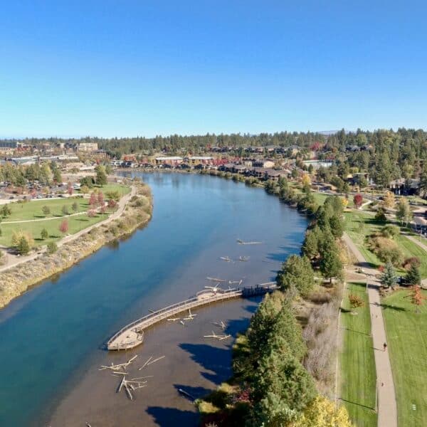
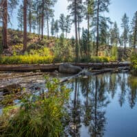
There’s a little sanctuary running through southeast Bend. It’s not conspicuous or flashy, just functional and well-loved. The Central Oregon Historic Canal Trail is a four-mile section of trail made of compacted gravel maintained by the Bend Parks and Recreation District. Wide enough for walking and talking side-by-side and graded gently enough for easy bike riding and wheelchair accessibility, the Central Oregon Historic Canal Trail meanders through neighborhoods, business districts, and natural spaces. (Please note that some grades are close to 8%, especially where the trail passes under Highway 97 and Brookswood Blvd underpasses.)
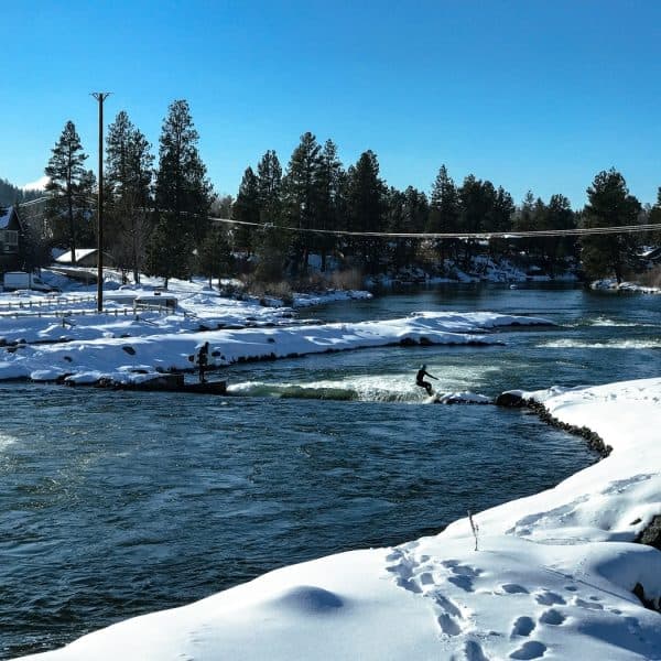
Residents and visitors often connect to the Canal Trail by simply walking or biking from their home, hotel, or vacation rental, then following the water-side path for as long as they feel comfortable. In summer, when the canal water is flowing, the trail offers a cool, in-town reprieve from the heat and a beautiful (albeit man-made) riverside walk or ride. In winter, when the canal is typically dry, the rocky indent can appear like a strange gouge cutting through town for those unfamiliar with the canal’s historic and contemporary function.
So, let’s go back in time. Since time immemorial, what is now known as Central Oregon has been the traditional homeland of the Wasco, Warm Springs, and Northern Paiute Nations, with frequent overlaps from neighboring Indigenous Nations. In the late 1700s, Spanish and Russian sailors were likely the first foreigners to set foot on the shores of the Pacific Northwest. In 1792, an American ship captain named Robert Gray, who had recently become the first American to circumnavigate the world, sailed his ship, the Columbia Rediviva, through a precariously dangerous sandbar guarding the mouth of an ocean-like river. He claimed “discovery” and named the river Columbia after his ship, which helped the United States establish a claim against Great Britain over the vast Pacific Northwest territories.
In 1805, President Jefferson and the U.S. government sent a military expedition led by Meriwether Lewis and William Clark to determine whether there was an all-water route connecting the eastern colonies to the Pacific Ocean. (One does not.) For decades, the British Crown and U.S. government argued over who should control the Oregon Territory, which includes current-day Washington, Oregon, Idaho, and parts of Montana and Wyoming, without considering the dozens of Indigenous Nations already controlling and compromising over these very important lands and watersheds.
While the Columbia River flows roughly 1,250 miles from its headwaters in British Columbia to the Pacific Ocean, ten major tributaries flow into the Columbia, including the Deschutes River. The Deschutes River begins at Little Lava Lake in the Cascade Mountains, roughly 30 miles southwest of Bend and 250 miles south of its terminus at the Columbia River. For millennia, these watersheds have served as critical trade and cultural highways for humans, fish, and migratory animals. When the United States and Great Britain signed the Treaty of 1818 with each other (and no Native nations), they declared mutual ownership over the western continent they had barely even traversed, agreeing upon joint occupancy of the Oregon Territory while setting a straight boundary line along the 49th parallel (which still marks the U.S.-Canadian border today).
In the following years, the United States signed hundreds more treaties granting land ownership to foreign countries like Russia, Spain, and the United Kingdom, as well as to domestic, often unwilling, Indigenous Nations. Two such agreements include the Oregon Treaty of 1846, which ended joint occupancy and placed lands above the 49th parallel under British control while lands below became American; and the Treaty of 1855, signed by members of the Taih, Wyam, Tenino and Dock-Spus bands of the Walla-Walla Nation, and the Dalles, Ki-Gal-Twal-La and Dog River bands of the Wasco Nation, which ceded ten million acres and reserved roughly 650,000 acres for the Warm Springs Reservation, located 65 miles north of Bend. The Treaty of 1855 continues to preserve tribal members’ rights to harvest and hunt in their usual and accustomed places.
Now that the United States “owned” the Oregon Territory, it needed to incentivize American citizens to occupy those newly taken lands. Except Central Oregon’s high desert landscapes are arid, and many Euro-Americans believed Oregon’s deserts and towering mixed coniferous forests were unfit for farming (they are.). So, the U.S. government devised various land acts to incentivize white American men to go make these lands “productive.”
The Desert Land Act of 1877 allows American citizens over 21 to apply for entry to develop arid and semiarid public lands in the West, up to 320 acres for $1.25 per acre. Unlike its predecessors, the Homestead Act of 1862 and the Preemption Act of 1841, the Desert Land Act does not require landowners to reside on their acreage but to simply “improve” the land by adding irrigation. Notably, the Desert Land Act has never been repealed, so it is still technically active today, which is great if only you could find 320 acres of unclaimed irrigable public lands in the West.
One year later, Congress enacted the Timber and Stone Act of 1878, offering 160-acre blocks at $2.50 per acre, free of preemption and homestead laws, thereby opening the West to single private owners who could buy huge tracts of land without having to live on them. While dozens of acts were being signed into law by Congress back in Washington, D.C., dictating how the American West should be used, these two acts were particularly transformative for Central Oregon.
Suddenly, white colonizers began to view the high desert as someplace with farming and ranching potential. Men filed paperwork and began building irrigation ditches and canals, envisioning new ways to move water through arid lands. Moving water, however, quickly introduced new dilemmas — particularly regarding sharing. If one person digs through desert sands and chips lava rock by hand, when newcomers arrive, do they have the right to use that hard-to-move water?
In 1877, Prineville became the first officially incorporated city in Central Oregon, followed by Sisters in 1888, Bend in 1905, and Redmond and Madras in 1910. Throughout the 1900s, dozens of irrigation ditches and canals were built communally, without engineers, mostly by private citizens who promised to irrigate their recently purchased acreage within five years.
In 1922, a group of local irrigation districts dammed the headwaters of the Deschutes River eight miles into its journey at Crane Prairie Reservoir, which was rebuilt in 1940 by the Bureau of Reclamation. Two miles later, the river is again stopped by the Wickiup Reservoir, built in 1949 by the Bureau of Reclamation, established in 1902 to manage water in the West. Because of these early incentivizing land acts that promoted the perceived need to irrigate and make all land farmable, the business of moving water in Central Oregon has always been, and remains, under private ownership. Many of these early infrastructures became the dams, canals, and irrigation systems we still use today.
Currently, eight irrigation districts draw from the Deschutes River watershed in Central Oregon. Senior water rights holders get full access and are the last to be shut off, while Junior water rights holders get, more or less, whatever’s left, which can sometimes be nothing in low-snow and drought years. Because seniority rights are based on years of establishment, the Deschutes River itself was only given legal rights to its own water in 1987, thanks to Oregon’s Instream Water Rights Act. Because of her late entry date (1987), the river is ironically considered one of the most junior water rights holders in the Deschutes Basin. However, the Central Oregon Irrigation District (COID), for example, does offer an “instream lease” option that allows property owners to maintain their water rights without fully irrigating their property each year. Instead, they can enroll acres and lease water back to the river, which COID makes sure is not diverted in the first place.
With so many communities, farmers, ranchers, and wildlife habitats vying for water, it is critical to step back and understand the complex history and modern-day functions of these canals. One organization that’s been navigating this tangle of privatization is Bend Parks and Recreation District (BPRD), whose goal is to establish a level of service that includes one mile of trail for every 1,000 residents in Bend (current population 108,000 and growing).
Double-dipping into the hundreds of miles of existing canal maintenance roads was an easy, if not ambitious, idea. “First and foremost, they are irrigation infrastructure,” says Henry Stroud, Principal Planner at BPRD. “But we also see these canals as the best opportunities to develop a comprehensive network of trails that are separated from traffic. Our focus has been on trying to acquire the rights to allow trail access, but the process is hard and complicated.”
Not only are the canals owned and operated by various private irrigation districts, but there are also federal permitting requirements to navigate with the Bureau of Reclamation, and many sections of canals run directly through private property, some of whose silent owners are difficult to track down. Some canals are also under the watch of state and local historic preservation organizations, creating additional considerations. Many sections of canals are being piped by irrigation districts to bring historically open trenches up to modern standards, reducing water loss to evaporation and seepage.
So far, the partnership between irrigation districts and BPRD has been mutually beneficial because, as Stroud explains, “We invest money and materials into improving those maintenance roads that allow the public to use them, which benefits the irrigation districts who patrol them almost every day while monitoring their irrigation infrastructure. We also add signage that tells the public where they can and can’t go with messaging around respecting the rights of the irrigation company because, first and foremost, these canals are irrigation infrastructure.”
With hundreds of miles of canal trails webbing across Central Oregon (COID, for example, manages 700 miles of canals in its district alone), BPRD sees significant potential to create more public trails that connect in the coming years. “Long term, we plan to extend the trail all the way out to 27th Street to some newer developments that are happening on the east side of Bend, but there’s been gaps where we haven’t yet been able to secure property rights,” Stroud says.
In the immediate future, BPRD is busy constructing its latest project: the North Unit Canal Trail. This 1.5-mile, ten-foot-wide, compacted-gravel trail in northeast Bend will connect Canal Park to Pine Nursery Park via Butler Market Road and parallel sections of the canal, which are jointly managed by the North Unit Irrigation District (NUID) and the Bureau of Reclamation.
Because all canal trails are subject to permissions by irrigation districts and private landowners, Stroud says, “Enjoy them, but be aware that they're really important pieces of infrastructure for the agricultural community and our entire community. Respect people’s property and respect the irrigation companies you see out there. The more people are friendly and nice on the trails, respecting private property, the more opportunities we’ll have in the future.”
To find more details about the Central Oregon Historic Canal Trail, the upcoming North Unit Canal Trail, and all future canal trail projects, visit Bendparksandrec.org.
See + Do
See + Do
See + Do

See + Do

See + Do

See + Do
See + Do

See + Do
See + Do
See + Do

See + Do
See + Do

See + Do
See + Do
See + Do

See + Do
See + Do
See + Do

See + Do

See + Do
See + Do

See + Do