


©2023 Savvy360, LLC. All Rights Reserved
PLAN A TRIP IN OUR APP

Austin White
Hit the Trails
Try these Central Oregon routes for classic trail experiences!
BY Gregg Morris
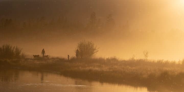
Each year, millions of people flock to Central Oregon to find inspiration in the Three Sisters Mountain views, take a stroll along the Deschutes River and float in the Cascade Lakes. Though it may have been the forest and river that beckoned European settlers to the region, it’s the miles and miles of trails that draw outdoor-loving visitors back year after year.
Hiking or biking on Central Oregon’s dirt, gravel or paved paths allows people to commune with both the flora and fauna of the region, from Juniper and Douglas Fir trees to Mule deer and yellow-pine chipmunks. Perhaps the region’s greatest strength lies in its accessibility to everyone, from the six-year-old who just shed their training wheels to their grandparent with decades of hiking experience. Whether your car has a full bike rack on top or simply a few pairs of hiking shoes in the back, the Bend area is ready for your next adventure.
For those looking for two-wheeled freedom, Central Oregon is a mountain biking mecca. Since 1992, the non-profit Central Oregon Trails Alliance has focused on “the development, protection and enhancement of the Central Oregon mountain biking experience” while overseeing more than 600 miles of singletrack trails for your enjoyment. COTA’s trails are anchored by the world-renown Phil’s Trail Complex in Northwest Bend whose 200+ miles of trails lead cyclists from the town’s lowlands to high into the mountainous backcountry. Pacific Northwest mountain bikers are well aware of the dirt jumps in the Lair and the curvy flow runs of the Whoops trail.
Outside of Bend, mountain bike trails can be found in just about every direction. To the south, the Sunriver Bike Path offers a paved 15-mile trail for a smooth ride. Looking east, Horse Ridge showcases hilly desert riding. An hour north will get you to Smith Rock State Park to tackle the steep and rough Burma Road Trail. And to the west, just outside the town of Sisters, lies the 15-mile Peterson Ridge Trail Loop, maintained by the Sisters Trail Alliance. Winter cyclists know to ride at Horse Butte or Redmond’s Maston Trail System when most other trails are buried under a few feet of snow.
Though the mountain bike trails are plentiful, hikers have even more options to get outside for some exercise. Some trails are shared with cyclists, but even more are reserved for foot travel only. Whether you prefer the urban, paved route or the backcountry dirt, Central Oregon has your day hike or multi-day backcountry experience ready for you.
Practically surrounding Bend lies the 1.6 million-acre Deschutes National Forest with a seemingly endless supply of trails. Even the crown jewel of the west, the Pacific Crest Trail, passes through the forest. Standing tall and providing picturesque views are the Three Sisters, Mount Bachelor and Broken Top. Scattered throughout the base of the mountains are countless number of lakes and waterways connecting them. Drive the Cascade Lakes Highway an hour outside of Bend and enjoy everything the forest has to offer.
East of Bend, the 29,000-acre Oregon Badlands Wilderness trails meander through ancient forests and volcanic features, as do the yellow-bellied marmots, bobcat and antelope. The Flatiron and Badlands Rock trailheads off Highway 20 provide access to over 50 miles of long and short treks for you and your four-legged friend. To the north, Smith Rock State Park has trails made for strolling and taking in the scenery as well as calf-busting climbs.
Central Oregonians who have had to carry their bikes over late-season snowfields or roll up their pant legs to cross a snowmelt-filled creek can attest to the importance of being prepared in the wilderness. Before heading out, make sure to check the appropriate websites (some are listed below) to look for trail closures and animal sightings. And don’t forget to support the local nonprofits who care for the trails you enjoy.
Don’t forget the 10 Essentials!
Navigation — map, compass, GPS
Light — headlamp + extra batteries
First Aid — medical supplies
Sun Protection — sunglasses, sunscreen, hat
Knife — and don’t forget repair supplies!
Fire — matches, lighter, flint + steel
Shelter — emergency bivy sack
Food — more than you think!
Water — way more than you think!
Clothing — expect extreme temperature changes!
A little preparation can mean the difference between discussing the day’s fun at a local brewpub and hunkering down in the woods waiting for the Deschutes County Sheriff’s Department Search and Rescue Team to come find you. Now, let’s look at some of Central Oregon’s iconic biking and hiking trails!
Before we begin, let’s review some mountain biking trail etiquette. Firstly, to maintain quality trails, don’t skid or hard brake, ride the dirt instead of mud and stay in the singletrack. Secondly, for everyone’s enjoyment, pack out what you packed in, yield to uphill traffic (and hikers and equestrians) and only ride open trails. And lastly, never modify the trail; always carry water, a tire tube and first aid kit and support your local trail nonprofit.
Deschutes River Trail - Dillon Falls to Benham Falls (Easy)
The Deschutes River Trail is a much longer system of trails that includes some areas in downtown Bend and outside of Central Oregon. But, for this easy ride, we will only cover the section between two picture-worthy spots, Dillon and Benham Falls. Head up Century Drive towards Mount Bachelor and take a left at Forest Service Road 41. Drive for about 2.5 miles and follow the signs to Dillon Falls.
Once you arrive at Dillon Falls, you’ll understand why this trail is guidebook worthy. Your first view is of the river pouring over boulders, around sharp corners, and down a 15-foot drop to become a class five rapid. It can be a little difficult to see but worth it when you find the right spot. After a quick view and picture, hop on your bike for a ride upriver and at times within 15 feet of the mighty Deschutes. The wide, 6.8-mile out-and-back trail has minimal elevation gain and no real technical issues to deal with. In addition to the many birds, sometimes you see local coyotes hunting in the spectacular meadow that the trail winds through.
Cyclists will begin to see lava flows on the far side of the river after riding a few miles. These lava flows were formed from Lava Butte after Newberry Volcano erupted 75,000 years ago. The lava and a few small river rapids alert riders to the upcoming Benham Falls where the river drops 60 feet through a narrow canyon. From here, turn around and head back to your car.
This trail is popular to both mountain bikers and hikers (and mosquitoes), so maintain awareness, be courteous and make sure to pack mosquito repellent. The Northwest Forest Pass is required for parking so pick one up at any local outdoor supply shop. Dogs are allowed but must be leashed May 15 through September 15.
Other easy rides to try: Shevlin Park Loop offers 4.6 miles of easy single-track, and Redmond’s Dry Canyon Path is relatively flat as it passes through a few local parks.

Ben’s Trail to Phil’s Trail Loop (Moderate)
Located minutes from downtown Bend off Skyliner Road and at an elevation of 3,881 feet, Phil’s Trail Complex is the treasure of Central Oregon mountain biking. And the 15-mile Ben’s to Phil’s Trail Loop gives riders a taste of what Bend mountain biking is all about. Beginning at the Phil’s Trail parking area, complete with restroom and information station, this loop has a nice flow of singletrack over dirt and lava rock, between tall pines, sagebrush and manzanita.
The one-way uphill Ben’s Trail begins at the trailhead and is a relatively easy 5.5-mile climb with a few lava rock switchback turns. There are several left turns to allow the rider to cut the ride short but continue up to Forest Road 300 for the full loop. Head south on the road to connect with Phil’s Trail, but if you’re feeling strong, continue uphill towards Whoops or Storm King. Phil’s Trail is a mostly downhill-reward for your climb. It’s not very technical but keep an eye out for slower riders as well as the iconic “Flaming Chicken” intersection.
If you’re not too keen on having to drive, there is a trail along Skyliner Road that many riders choose to leave the Subaru at home. Careful with your timing, as the parking area can get crowded, and the trail can become sandy and dusty as summer heats up.
Other moderate rides to try: Phil’s Trail Complex has many trails suitable for the average mountain biker. Check out the map at the trailhead and go!
North Fork to Mrazek Trail (Difficult)
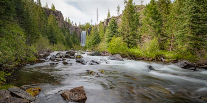
Start your 19-mile ride at the picturesque Tumalo Falls. Climb four miles and pass seven more waterfalls on the uphill-only North Fork Trail. Connect to Mrazek via the one-mile Metolius-Windego (Met-Win) trail before taking a right and beginning your descent back to Bend. Another option is to take the Farewell Trail to Mrazek, but you’d miss the scenic North Fork Trail.
The full Mrazek ride is mountain biking heaven. It’s a long, cross-country trail through the Tumalo Creek drainage and down to Phil’s Trail Complex or Shevlin Park, depending on your turn at the bottom. Keep your wits about you as the Mrazek Trail travels over logs, ramps, bridges, rocks and roots, and through sage brush, pines and manzanita. There’s even a rocky, technical, switchback section at the end of the trail. Pure fun!
Other challenging rides to try are Flagline Trail which starts near Mount Bachelor, connects with Swede Ridge and then a few Phil’s Trail Complex trails for a 22-plus-mile journey back to Bend. Or try the Funner Trail in the Wanoga Trail System for some rocky and tough terrain.
For those looking to take a day off from the trails and get in some road riding, Central Oregon has a few Oregon Scenic Rides out its backdoor. Both the Twin Bridges Loop and the Smith Rock to Sisters rides offer around 35 miles of pavement below and views all around.

Central Oregon hiking trails range from desert sand to packed dirt to rocky lava pumice. Some trails have dog restrictions while others allow for your four-legged friends. Don’t forget to follow the rules and be courteous to others. Remember that uphill hikers have the right of way on shared trails; hikers yield to horses and cyclists yield to both hikers and horses; and don’t forget your 10 Essentials!
Tumalo Falls (Easy)
Drive Skyliner Road about 12 miles west of Bend to reach the parking area for the spectacular 97-foot Tumalo Falls. While there is a daily five dollar fee, it does include toilets and a picnic area. This short hike to the viewpoint allows for an iconic Bend photo as well as views of the Tumalo Creek Watershed area. Do yourself a favor and look up the incredible restoration process the creek and surrounding area has gone through since the 1979 Bridge Creek Fire.
If you feel like adding some hiking miles to your day, head up the North Fork Trail for more waterfalls, but be aware of the mountain bikers also using this uphill trail. An option is to turn around and walk along the Tumalo Falls Loop Trail to see Tumalo Creek in action. This leisurely trail offers more views of the drainage area’s rock walls and forested floor.
If an easy hike is more your speed, there are plenty of options in Bend. Take a stroll along the Old Mill Trail and watch the river surfers at the Bend Whitewater Park or stand-up paddle boarders in the Deschutes River. For more of a nature walk, head to Northwest Bend’s Shevlin Park for its old-growth forest and high desert sagebrush.
Green Lakes/Soda Creek (Moderate)
One trip into the Green Lakes area via the nine-mile Green Lakes Trail/Soda Creek Trail Loop and you will instantly understand why it’s the most popular hike along the Cascade Lakes Highway. Your mileage will increase with your desire to hike around the scattered lakes lying beneath the Broken Top and South Sister mountains. Known for its day-hike and backpacking options, the Green Lakes/Soda Creek hike travels along Fall Creek and passes through wildflower meadows and along lava flows.
The limited passes sell out early for the most popular weekends, but it’s worth it if you can score one. There are campsites scattered throughout the Green Lakes area if you’re looking to spend the night. And if you’re looking for a real adventure, try the Three Sisters Loop that includes this area plus some time on the nearby Pacific Crest Trail.
For more moderate trails, head west of Sisters and hike along the Metolius River Loop for a relaxing 5.4-mile stroll to see the Wizard Falls Fish Hatchery or the many fly fishermen trying their luck in the cold river; or hike the Broken Top Trail to No Name Lake, and put yourself high in the alpine region of the Deschutes National Forest.
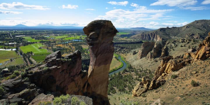
Misery Ridge (Difficult)
Though not very long, Smith Rock State Park’s Misery Ridge Trail is listed as difficult because of the stair-climbing and potential for intensely hot days in the summer, as well as the number of search and rescue operations performed there each year. But if you decide to take the leap and hike the four miles of landscape created by Oregon’s largest volcanic eruption 29.5 million years ago, you will be rewarded with views, both inside and outside the park. The start of the trail showcases Picnic Lunch Wall and the many rock climbers clinging to it each day. Switchbacks and steps lead you pass the rocky Shiprock and the Red Wall and on to the Misery Ridge Summit and the appropriately named, 350-foot Monkey Face climbing spire. Don’t forget your camera and look for any high-wire slacklining in the park. Head back down via the Canyon Trail, Mesa Verde Trail and the River Trail to return to your car.
Since this hike is within an Oregon State Park, there are day-use fees, and sometimes it gets crowded on the weekends and holidays. But the Cascade views of Mount Bachelor, Broken Top, the Three Sisters, Black Butte, Belknap Crater, Mount Washington, Black Crater, Three Fingered Jack and Mount Jefferson make it all worth it!
For more challenging trails, drive towards Mount Bachelor and park at Dutchman Flats to tackle Tumalo Mountain. On a clear day, your reward for the four-mile, up-and-back-down trail is a 360-degree view of all of the area’s mountains, as well as surrounding cities. If you’re feeling strong, cross the street and hike to the 9,065-foot peak of Mount Bachelor!